News

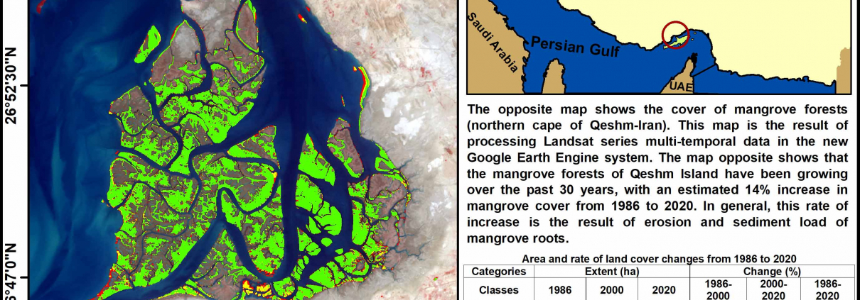
New paper has been published in Scientific Reports, Nature

A new paper with collaboration of the members of the Remote Sensing Laboratory, University of Tabriz has been published in Scientific Reports, Nature. You can freely download the paper from the link below:
https://www.nature.com/articles/s41598-022-10159-2

30-year monitoring of mangrove forests in southern Iran (Qeshm Island)

The rate of change in Qeshm mangrove forests (QMF) has been increasing over the past 30 years, and this increase is more evident in the southern and eastern parts of Qeshm Island.


Light pollution extracted from night time light data for Tabriz

Light pollution in Tabriz has increased from 2012 to 2020, which is more noticeable in the eastern and southwestern areas of the city. Billboard lights, street and highway lights, urban element lights are the main sources of light pollution.

Monitoring of maritime traffic during the outbreak of Covid-19 in the Strait of Hormuz and the Bandr-e-Pol


Ship extraction maps from Sentinel-1 SAR data show the direct impact of Covid-19 on the maritime transport industry, which in turn has led to a reduction in maritime traffic in the Strait of Hormuz in 2020.

Impact of Covid-19 on Urban Heat Island (UHI) of Assaluyeh Industrial Zone with Landsat 8 series of images

The impact of Covid-18 during, before and after the epidemic in western Assaluyeh (industrial area) is shown in the UHI map prepared from Landsat 8 images.

GIScience webinar in the occasion of GIS-day will be held in 17 November 2021.

GIScience webinar in the occasion of GIS-day will be held in 17 November 2021.

Remote Sensing webinar with Azerbaijan National Academy of Science (Part 2)

In November 2021, the head of the RSLUT, Dr. Sadra Karimzadeh held a webinar for Institute of Geography of Azerbaijan National Academy of Science. Dr. Karimzadeh explained various applications of synthetic aperture radar (SAR) remote sensing such as: building damages after earthquakes, water pollution, etc.

Remote Sensing webinar with Azerbaijan National Academy of Science (Part 1)


In October 2021, RSLUT member Prof. Khalil Valizadeh held a webinar for Institute of Geography of Azerbaijan National Academy of Science. Prof. Valizadeh explained various applications of multi-spectral and thermal image analysis for different purposes.

Initial interferogram of Japan’s northwestern Chiba earthquake (M 6.1)

Initial interferogram of Japan’s northwestern Chiba earthquake (M 6.1). Sentinel-1 orbit 141 covers some parts of eastern coast of Japan. Some atmospheric effects can be observed in the results.