Loading
Remote Sensing Laboratory
  • Home
  • Contact
  • Members
  • Publications
  • Equipment
  • Click to open the search input field Click to open the search input field Search
  • Menu Menu

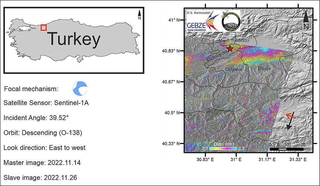
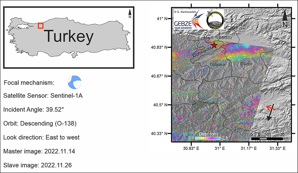
Mw 6.1 Duzce Earthquake InSAR analysis

November 28, 2022/in News/by admin

Tags: duzce, earthquake
Share this entry
  • Share on X
  • Share on WhatsApp
  • Share on LinkedIn
  • Share by Mail
https://rslut.ir/wp-content/uploads/2022/11/duzce-1.jpg 599 1030 admin https://rslut.ir/wp-content/uploads/2026/04/rslut-300x300.jpeg admin2022-11-28 21:28:162025-02-27 18:10:15Mw 6.1 Duzce Earthquake InSAR analysis
You might also like
Initial interferogram of Japan’s northwestern Chiba earthquake (M 6.1)

Pages

  • Contact
  • Equipment
  • Home
  • Members
  • Publications

Categories

  • Equipment
  • Links
  • News
  • Publications

Archive

  • December 2025
  • October 2025
  • September 2025
  • July 2025
  • April 2025
  • February 2025
  • January 2025
  • December 2024
  • July 2024
  • June 2024
  • April 2024
  • January 2024
  • October 2023
  • September 2023
  • August 2023
  • June 2023
  • April 2023
  • March 2023
  • February 2023
  • December 2022
  • November 2022
  • August 2022
  • April 2022
  • February 2022
  • January 2022
  • November 2021

Archives

Categories

Categories

  • Equipment
  • Links
  • News
  • Publications
© Copyright - Remote Sensing Laboratory
Link to: 5. Karimzadeh, S., Ghasemi, M., Matsuoka, M., Yagi, K., Zulfikar, A. 2022. A Deep Learning Model for Road Damage Detection after an Earthquake Based on Synthetic Aperture Radar (SAR) and Field Datasets. Journal of Selected Topics in Applied Earth Observations and Remote Sensing, IEEE, doi: https://10.1109/JSTARS.2022.3189875. Link to: 5. Karimzadeh, S., Ghasemi, M., Matsuoka, M., Yagi, K., Zulfikar, A. 2022. A Deep Learning Model for Road Damage Detection after an Earthquake Based on Synthetic Aperture Radar (SAR) and Field Datasets. Journal of Selected Topics in Applied Earth Observations and Remote Sensing, IEEE, doi: https://10.1109/JSTARS.2022.3189875. 5. Karimzadeh, S., Ghasemi, M., Matsuoka, M., Yagi, K., Zulfikar, A. 2022. A... Link to: 6. Karimzadeh, S., Valizadeh Kamran, Kh., Mahdavifard, M. 2022. A Multisensor Satellite Image Classification for Detection of Mangrove Forests in Qeshm Island (Southern Iran). Applied Geomatics, doi: https://10.1007/s12518-022-00475-7 Link to: 6. Karimzadeh, S., Valizadeh Kamran, Kh., Mahdavifard, M. 2022. A Multisensor Satellite Image Classification for Detection of Mangrove Forests in Qeshm Island (Southern Iran). Applied Geomatics, doi: https://10.1007/s12518-022-00475-7 6. Karimzadeh, S., Valizadeh Kamran, Kh., Mahdavifard, M. 2022. A Multisensor...
Scroll to top